This year marks the 250th anniversary of the Battle of Brooklyn. It is also known as the Battle of Long Island, but over the years many people have started referring to it as the former, since the battle took place within what is now Kings County, or Brooklyn. At the time of the battle, the western tip of Long Island was sparsely populated and filled with farms and small villages. Several of these villages were involved directly or indirectly in the battle that was fought on August 27th, 1776.
Brooklyn historians, who were every bit as fascinated with the battle as I am, compiled books with interviews and observances from soldiers who fought in the American Revolution, their widows, family members, and other eyewitnesses, as they, like historians do today, grappled with the meaning of the war and how it impacted the folks living in the area, Patriot and Loyalist alike. These historians, in this effort, both figuratively drew upon, and in some instances took it upon themselves to literally draw maps of the battle, significant fortifications, and the notable features and structures around in 1776.
In anticipation of the anniversary, here are some of those maps. Studying these can provide excellent insights to historians and anyone who is curious about the battle, and show the locations and relations of the hallowed places like “Battle Hill,” “the Old Stone House,” and the line of defenses protecting Brooklyn Heights, and eventually the American Army, from complete destruction by the British army following the battle itself.
Two additional maps and their descriptions can be seen here.
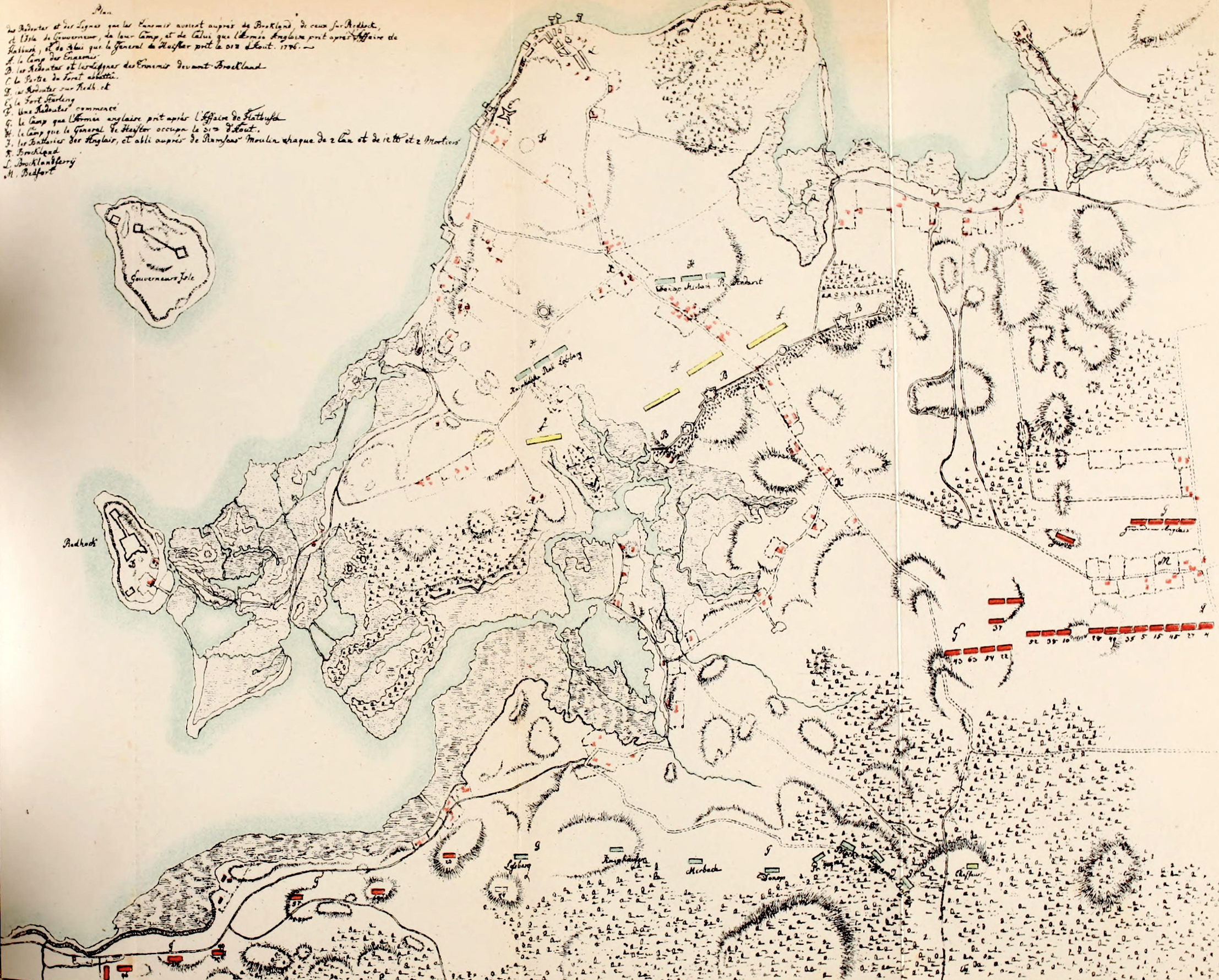
Description of the map from the mapmaker, T.W. Field: “This plan, the work of a Hessian officer, was drawn shortly after the occurrence of the battle. The following is a translation of the table of description:
Plan of the redoubts and lines which the rebels had erected near Brookland; of others on Red Hook and Governor’s Island; of their camps occupied by the rebel and English armies after the affair at Flatbush, and that were [sic] occupied by General De Heister on the 31st of August, 1776.
A. Camp of the Enemy (i.e. the Americans).
B. Redoubts and lines of the Enemy before Brookland.
C. Part of the abatis; forest cut down.
D. Redoubts on Red Hook.
E. Fort Stirling.
F. Unfinished redoubt.
G. The camp occupied by the English army after the affair of Flatbush.
H. The camp occupied by General De Heister on the 1st of August.
J. Batteries established by the English near Remsen’s mill, each of two twelve-pound guns and two mortars.
K. Brookland (junction of Gowanus, Flatbush and Jamaica Roads).
L. Brookland Ferry
M. Bedford
The topographical outlines of the plan were taken from the Ratzer Map, to which the military details were added at some point subsequent to the battle. It will be observed that the line of American entrenchments as given by the Hessian officer do not correspond entirely with those upon the plan compiled for this work. On a plan drawn upon a scale so small, but few of the details of the various positions could be given. The general line of fortifications is the same in each plan, but in the larger one, the natural defensible line has been followed, as nearly as it could be authenticated by documentary and traditional evidence.”
From The Battle of Long Island, with connecting preceding events by Thomas. W. Field.
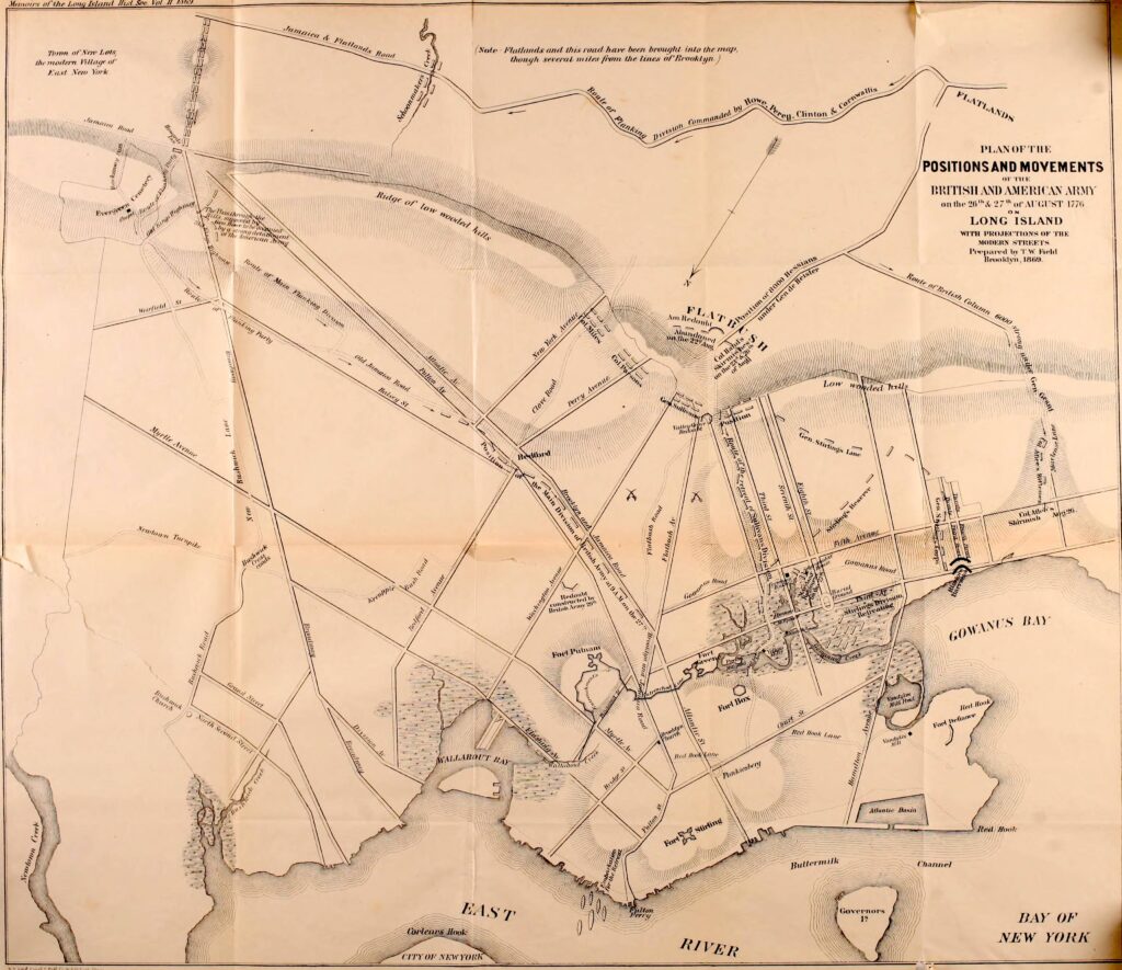
Plan of the Positions and Movements of the British and American Army on the 26th and 27th of August 2776 on Long Island, with Projections of the Modern Streets. Prepared by T.W. Field, Brooklyn, 1869.
This unique map, drawn by historian T.W. Field in 1869, shows the defences protecting Brooklyn Heights, along with some of the smaller redoubts along the passes through the Heights of Guan. It is oriented with the south/southwest on the top right, which provides a unique view of the directions from which the British and Hessians came from during their attack. General Grant came up the Gowanus Road, General de Heister came through the Flatbush Pass, and Generals Howe, Percy, Clinton, and Cornwallis came along the Jamaica Road. These three attacks in concert caused the Americans to retreat back towards the Gowanus Creek and marsh surrounding it, and were it not for General William Alexander (Lord Stirling) and the stand of the famous Maryland Regiment at the Old Stone House, the day could have been a complete rout for the Americans.
Description of the map from the mapmaker, T.W. Field: “This plan of the positions of the British and American armies, and the redoubts and lines of fortification, is compiled from the most authentic sources of information available. The route of the British were generally over country roads long since abandoned and now covered with buildings, but their localities were accurately surveyed by the author before their traces were lost.”
From The Battle of Long Island, with connecting preceding events by Thomas. W. Field.
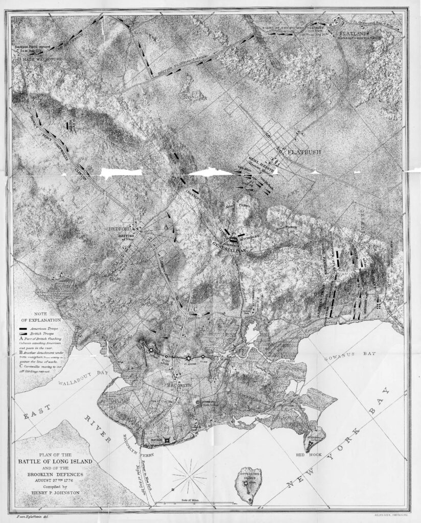
Plan of the Battle of Long Island and Brooklyn Defenses. This map, drawn by historian Henry P. Johnson, shows the defensive line anchoring Brooklyn Heights, along with the key movements that occurred during the battle. The solid rectangles denote the Americans, and the black and white rectangles represent the British and Hessians. The pincer attack can be seen at letters A: when the Americans realized the enemy was behind them; B: a force approaching the American inner defenses; and C: the British cutting off General Stirling and attempting to prevent the American retreat.
This map offers useful insights as to how the American lines collapsed, and shows the approximate route of the retreat on the 27th.
From The Campaign of 1776 Around New York and Brooklyn by Henry P. Johnson.
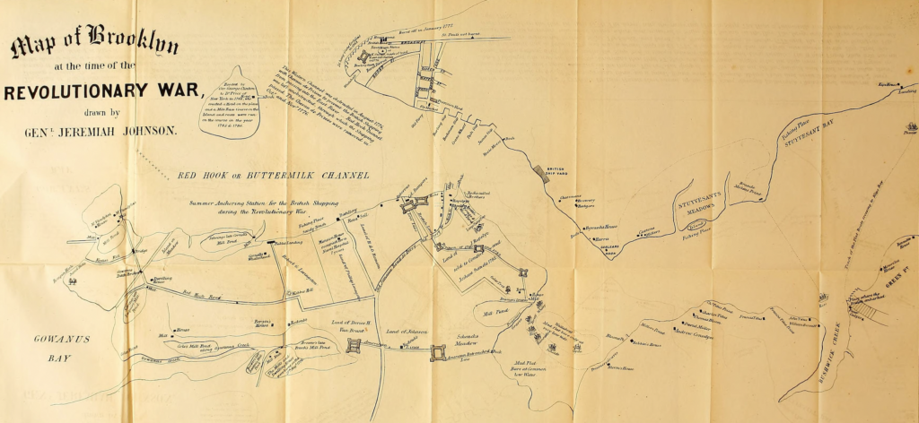
Map of Brooklyn at the time of the Revolutionary War, drawn by Gen Jeremiah Johnson. This map shows several of the fortifications that the Americans constructed in early 1776 and manned during the battle. After the American retreat on August 29th, the British took over the forts, utilizing some of them and destroying others. This view also shows the Wallabout Bay and several of the prison ships that were moored there.
The accompanying description reads: “The ships of war which covered the landing of the British Army at Kip’s Bay on the 17th Sept. 1776 was the Phoenix, the Rose, and Duchess of Gordon. The Phoenix and Dutchess passed up the river on the evening of the 16th with the Flatboats rowed by seamen. On the morning of the 17th the ships took their stations about 250 yards from the land. About ½ past 8 o’clock the ships began a tremendous fire on the shore to scour it, which continued about an hour.
The troops embarked on the beach at Peter Calyers and crossed on the flood near high water and landed at Kip’s Bay. Whenever the boats passed the ships the firing ceased. The landing was finished by about 10 o’clock. The weather was fine. Kip’s house was damaged. Four families from Bushwick which had fled there for safety fled into the cellar to save their lives. Thomas Skillman, Jaco Tolovin, and John Vandervort were taken at Kip’s and confined in the prisons in New York.
In the evening of Sept. 12th 1776 the British frigate Rose passed up the East River through Buttermilk Channel and anchored opposite to Bushwick Creek. On the 13th the Americans threw up a small breast work on Brande Molen’s Point and about 4 o’clock mounted 2 heavy guns on the work and opened their fire on the frigate. The first shot skipped over the hull, cut off her gunnell, and killed a cow taken from Jacob Polliemus, who was on board. The Americans then fired 17 shots into the frigate. Night saved the ship from destruction. The frigate returned the fire without effect. In the night the ship took a station between Blackwell’s and Long Islands.
The Whitby prison ship was moored in the Wallabout Bay in October 1776 and was a prison ship until 1777 when the Scheldt and the Clyde were moored in the Bay, and the prisoners were transferred to those ships. The Scheldt was burnt on a Sunday afternoon in October 1777 and the Clyde was burnt in February 1778. The prisoners who were living were then removed to ships then laying in the Bay. The Jersey with the Hope and Falmouth were moored in the Bay in April 1778. The Jersey was the receiving prison ship. The Hope and Falmouth were hospital ships to the year 1783.”
From D.T. Valentine’s Manual of the Corporation of the City of New York, 1858.
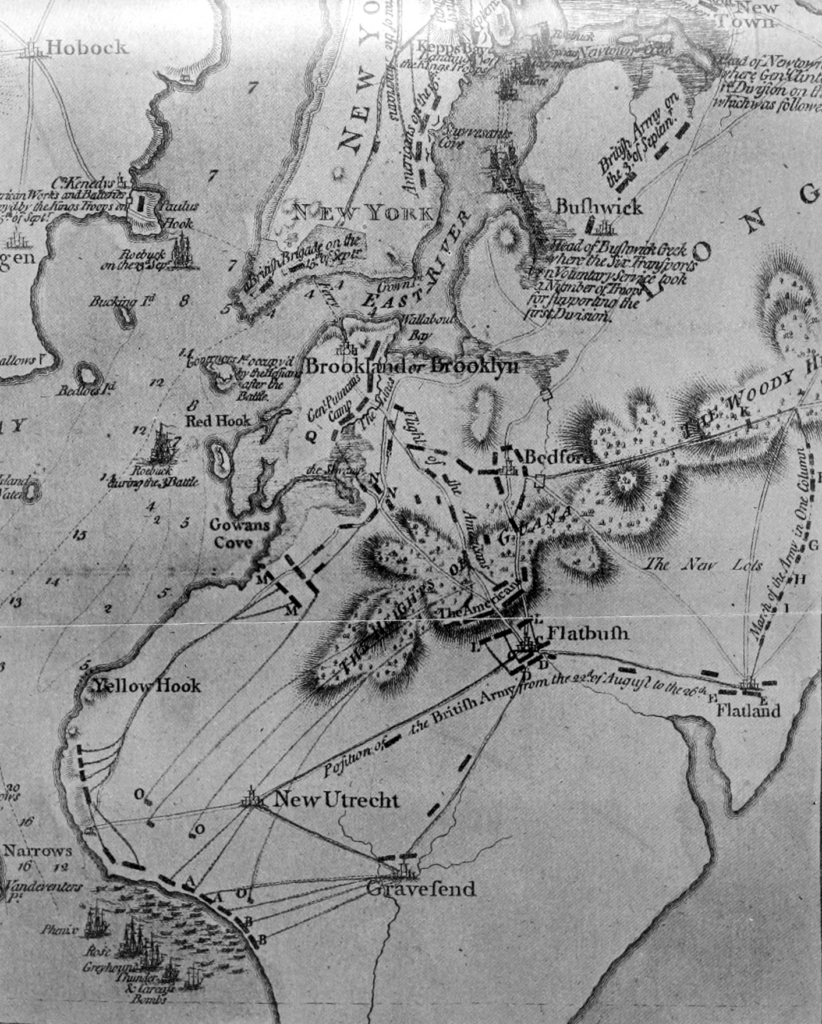
An excerpt from a map “Engraved and Published According to an Act of Parliament, October 19th, 1776 by William Faden.”
Key to the map (from The Bulletin of the Brooklyn Institute of Arts and Sciences, Volume 4, 1910):
AA. Landing of the British with 40 pieces of cannon on the 22nd of August
BB. Landing of Hessians under Lt. General De Heister, on the 25th of August
CC. Lord Cornwallis with the reserve, two battalions of Light Infantry, on the 22nd
DD. Lt. General De Heister, with his two Brigades, on the 26th
EE. Lord Cornwallis with the British on the 26th
F. Lt. General Clinton with his van, consisting of Light Dragoons and Brigade of Light Infantry
G. The main body under Lord Percy, consisting of the 3rd and 5th Brigades with 10 field pieces
H. The 49th Regiment
I. The baggage and its separate guard
K. A battalion of Light Infantry securing the pass
L. Lt. General De Heister attacking the front of the enemy
MM. Maj. General Grant with the 4th and 5th Brigades, the 42nd Regiment, and two companies of New York Provincials, with 10 pieces of cannon, attacking a large Corps on the enemy’s right
NN. A party of the Independent Grenadiers, supported by the 71st Regiment
OOO. Small parties of the enemy on the coasts, who, on the approach of the boats, retired to the Woody Heights
Q. American Lines in Brooklyn
From The Stone House at Gowanus, Scene of the Battle of Long Island by Georgia Fraser, 1909.